UAV LiDARCompleted
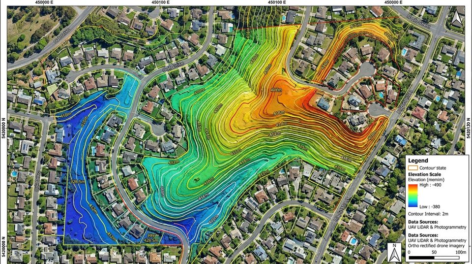
Borrowdale North Topographic LiDAR
Borrowdale, Harare
UAV photogrammetry and a digital terrain model for a residential development and its drainage masterplan.
Technology & Geospatial
Drone surveys capture large or hard-to-reach areas quickly. We fly, process and deliver the data in formats your engineers and planners already use.
Used in: Construction & property developmentMining & quarryingAgriculture & agribusinessEnvironmental & natural resourcesInfrastructure & engineering
High-resolution, georeferenced aerial images of your site.
Dense 3D point clouds that see the ground under vegetation.
DTM and DSM outputs for design, drainage and earthworks.
Contour lines at the interval your design needs.
Cut-and-fill and stockpile measurements for construction and mining.
Repeat flights to track construction or land-use change over time.
You tell us the location, what you need and any deadline — by form, email, phone or WhatsApp. We ask what we need to know.
Where the work needs it, we visit or review the site, existing plans and records before pricing.
A written scope and quotation with dates. Every quotation carries a QR code you can check online.
Once you accept, we book people, equipment and materials and agree the programme with you.
Survey, mapping, software or building work is carried out, with progress, files and messages in your client portal.
Final deliverables, plans or keys, with the invoice and receipt kept together in one place.
Borrowdale, Harare
UAV photogrammetry and a digital terrain model for a residential development and its drainage masterplan.
Samora Machel Ave, Harare
Volumetric building models and utility-corridor mapping for municipal urban management.
Point density, volume accuracy and cost across large concessions.
ReadSpatial databases, analysis and clear maps built from survey, drone and satellite data.
View serviceSatellite and drone analytics, crop monitoring and automated document processing.
View servicePlanning, contractor coordination, scheduling, budget tracking and reporting.
View serviceSend the location and what you need. We reply with next steps and, where possible, a quotation.